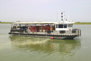
 SSAL is well- equipped to carry out seismic survey (2D, 3D or 4D) in all terrains. Our services range from parameterization through field design, permitting, positioning, shot hole drilling to data acquisition and in-field analysis of acquired data quality.
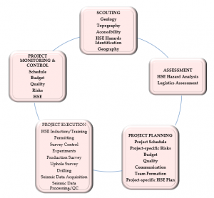
With the nodal recording technology and stake-less method, we help reduce the cost, risk profile and environmental footprint of clients’ surveys. We apply standard project management processes to all components of our exploration programs, from planning to execution of field activities.
Good Signal to Noise ratio (S/N), resolving power and adequate spatial coverage of the target are characteristics of good quality seismic data.
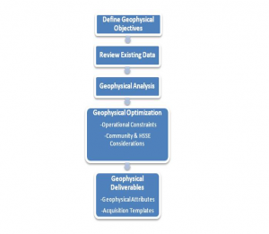
To get the best survey parameters/field design that can produce good seismic data, we tap on an arsenal of technologies, from integration of well data to ray tracing. The resultant design will impact the geophysical imaging, costs, schedule and HSSE components of the project. Field conditions are applied to the theoretical parameters/field design to fine-tune them.
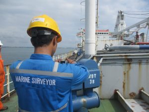
Detailed geophysical surveys and assessments of the sea bed and sub-sea bed are critical in risk assessment and cost-effective design of marine structures and subsea installations.
SSAL offers an integrated approach, combining data from bathymetry, sea-bed morphology, geology and geotechnical to identify geohazards and constraints affecting the design, construction and long-term reliability of marine infrastructures
Integration and interpretation of the various types of data are managed in a GIS environment. A GIS database is populated with the ‘strata’ of information collected
using the various investigation tools. Thus, a 3D ground surface and subsurface model is developed. This model is used to carry out detailed risk assessment.
Applications
- Oil and gas well drilling
- Oil producing platforms
- Oil pipeline route
- Installation of offshore wind farms
Mineral Exploration
Locating a new mineral deposit and delineating its extent and grade, is the hardest part of the job for a mining geologist. For mining to be sustainable, the mineral deposit must be economically viable, and ore production needs to be guaranteed over a long period of time. Even after the commencement of mining, it is necessary to locate and delineate any extensions to the mineralization, and to search for new prospect that may replace the reserves being mined.
SSAL has what it takes to prospect and explore for mineral deposits. We are involved in the following:
- Exploration Project Management
- GIS and remote sensing
- Integrated geoscience surveys (geological mapping, geochemical and geophysical surveys)
- Exploratory drilling, geophysical well logging and sampling
- Reserve estimation
Geotechnical Assessments for Mine Planning
Geotechnical risks in mines arise from ground movement during and following excavation. Subsidence, landslips, settlement, heave, slumping and fracturing are examples of ground movements. It is important that mines are operated, rehabilitated and closed in a manner that does not pose an unacceptable risk to public safety, infrastructure and the entire environment. Thus, it is only appropriate that a work plan addresses the identification of such risks and their control and mitigation.
SSAL conducts a geotechnical risk assessment prior to the commencement of mining, developing a geotechnical model of the area.
We delineate the potential area of ground movement around the mine
Look around for the existence of surface features that may be affected by or affect mine induced ground movement
Assess the geological and hydrogeological data of the area
Search for the existence of subsurface features that may be affected by or affect mine induced ground movement
Obtain information on the strength, compressibility, durability and quality of the ground to be mined or removed.
Our subsurface investigation tools are largely non-intrusive, and few CPTs (Cone Penetrometer Tests) are carried to constrain interpretation.
Geotechnical Assessments for Infrastructure
The current practice by many geotechnical investigators is to drill/conduct CPTs at discrete positions within a development site. This method generates data gaps, as the nature of the geological material, between these sampling points are unknown. The geological material may be that of low shear strength; further increasing the risk profile of the site.
Our equipment is non-intrusive, and consists of a cost-effective vibroseis energy source and land streamer of 72 3C (3 component) sensors. Continuous subsurface profiles are generated down to depth of 200m. These are interpreted in terms of shear moduli, MASW and p-wave data. There could be direct fluid detection by combining P-wave and S-wave data in a single pass. The interpretations are constrained by very few CPTs.
Advantages
Our method costs less than the intrusive methods of drilling and CPTs. The subsurface profiling reduces the number of penetration tests required, optimizing their positioning.
Areas of weak soil strength identified on the subsurface profiles should reduce the risk profile during and after the site development.
The method is non-intrusive, and therefore, environment-friendly.